Home ELECTRICNAUTICAL TOOLS/ELECTRONICSCHARTPLOTTERS
Back to all products


NAVIONICS PLATINUM+ XL3 MULTI-DIMENSIONAL CARTOGRAPHY
Navionics Platinum+ Multidimensional electronic cartography which adds to the extended coverage and detailed information of Navionics Gold XL9 Charts following new characteristics:
Three dimensional sea bed and land elevation / Standard Bathymetrics (for high resolution see SonarCharts) / Top-down satellite and aerial images / Panoramic portpictures / Georeferenced Coast Pilot / Detailed port service guide / Coastal road networks and detailed Points of Interest / Dynamic presentation of Tide & Currents / Detailed wreck database.
Available in XL3 cartridges CF (Compact Flash) and SD/MicroSD (Secure Digital)
N.B. Other coverage upon request.
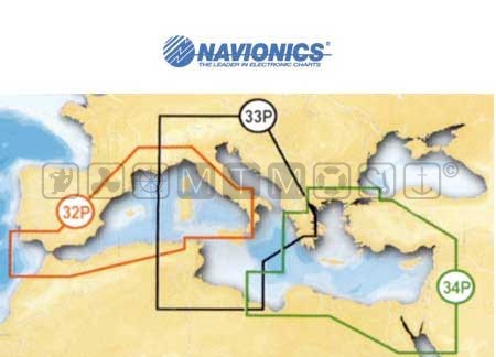
| Code | Copertura | Formato | Price | In Cart |
| 5625925 | 32P Mediterraneo Occidentale | CF | 368,44 | |
| 5625926 | 33P Mediterraneo Centrale | CF | 368,44 | |
| 5625927 | 34P Mediterraneo Orientale | CF | 368,44 | |
| 5625932 | 34P Mediterraneo Orientale | SD/MicroSD | 368,44 |